Saturday, September 29, 2007

9-28-07 Olympia National Forest: Lower Ellinor Trail


Well, we drove all the way out toward Staircase, made a right instead of a left and ended up at Olympic National Forest's Mt. Ellinor Trail.


Saturday, September 22, 2007

9/22/07--Olympic National Forest: Lower Lena Lake

This was the second time we did this hike. All I can say is WOW! This time it didn't seem nearly as grueling. I think I had psychologically prepared myself for it to be intense. As a result, it wasn't! We didn't even stop for any breaks this time except to take pictures!

That said, one internet guide actually describe this hike as "easy". And even though we were out of shape the first time we did this trail, I still don't think it would be fair to classify this as "easy". Eh, I guess it's all relative.


Anyway, the end result is the fabulous view you can see in the pictures here. And they really don't do the scenery justice.

It took us about an hour and a half to hike to Lower Lena, and a little over an hour to get back.


To the left here is Evan sitting in the neat rock cave/ formation thing about 3/4 of the way up the trail. He's mad because there was too much Steve Miller playing on the drive up and so he decided to go protest in this cave ;)

Look at how beautiful this is!

Directions, info and ETCETERA


i'm gonna fly like steve miller, through the trees

Sunday, September 16, 2007

9/14/07 Olympic National Park: Staircase

note: i lifted the picture to the left from here. still haven't gotten a camera.

Finding ourselves with an unexpected "free" day, we took off toward Staircase in Olympic National Park. It was a wonderful drive up, and we were even able to see some sunlight as we cruised around Lake Cushman. I didn't really know the story of the lake, or the Skokomish river until after we returned. Here is some interesting reading. And also here.

The river was low; also the bridge was out on the Staircase loop. We still hiked in and then climbed down onto the rocks, getting really close to the falls. Unlike the log/river incident at the Lower Skokomish, the rock climbing/ hovering over the river stunts scared me more than Evan. I just kept thinking we were going to tumble into the falls and well that would be it! I know that's stupid, but the rocks were slippery and well, whatever. Evan wanted to climb down so I went with him. Ultimately though I was glad to get back on the trail. After that we hiked through more old growth and well into the area where there had been a fire in 1985 (1986?).

It was a good afternoon walk, a very,very easy "hike" if it can even be called that. If this trip could be summed up in one word it would probably be "magical". There is a bunch of old growth the first mile or more into this trail. As we did this walk I was hyper aware of how fast the landscape can change. All of the snow damage, along with the burned up stumps and rotted out trees; all of the erosion and the sliding of giant trees down green mossy slopes into the river-- all of it was amazing! We had fun!

Friday, September 14, 2007

9-8-07--Olympic National Forest: Lower South Fork Skokomish Trail


We hit the road around 12:30pm and drove north on 101, determined to randomly hit the first trail we saw that was inside National Forest. After about a half hour we saw the first sign that would lead to a trailhead. We drove another 15 miles west until we hit the forest and soon after found ourselves at the entrance to the Lower Skokomish Trail. On the way in we drove passed the place where the logging camp had been before the forest was protected. We could see how many trees around the forest had been taken. It was pretty intense.

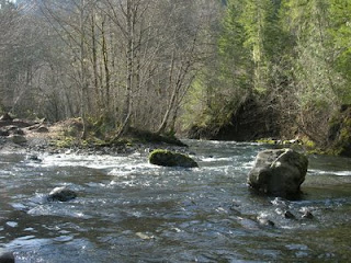
As much as I love Mt. Rainer, this has to be my favorite hike so far. Parts of it in the beginning were pretty intense, but then it leveled off into gradual hills. The forest here is simply breath-taking. The air was dense, and the sunlight filtered through the many shades of lush green. There was at least one mini water fall and best of all, the Skokomish river. The water was low but you could see where it might rise during the rainy season. There was a log that had either fallen or been placed across the river. We veered off the trail and ignoring Evan, I decided to climb on top of it. I don't know what came over me, I just wanted to climb on top of the log and be over the water. Thinking back, it was almost like I was bewitched. Ultimately though, it was dangerous as hell, and I didn't want to freak Evan out, so I came back.

On the way home we stopped at the salmon hatchery, something neither one of us had seen before. It was really wild to see so many salmon jumping out of the water at the same time, glimmering in the loose sunlight, while the water reflected the trees. To top it off, a heron was perched on the fence nearby, watching all of the fish (in great frustration!) move back and forth from the air to the water, again and again.

After doing some research on this trail and the river, I have discovered that the river often floods. Evan and I haven't bought a camera yet; once we do we want to go back and take pictures.

More info:
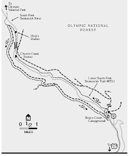
Elevation Gain in: 650 ft
Elevation Gain out: 250 ft
Trailhead Elevation: 800 ft
Maximum Elevation: 1200 ft

Difficulty: Moderate

Attractions
:
Old Growth
River

Directions:

8-29-07--- Mt. Rainier National Park: Reflections Lakes Trail


This hike almost didn't happen. It was spontaneous and unplanned. The sun was out and I suddenly had this terrible realization that summer was almost over and soon the rain would be back for months and months. We jumped in the car around noon and made very good time, getting to the park entrance around 1:30pm, and getting up to Reflections Lakes soon after.

We didn't really know what we were doing, and started hiking around one of the lakes on the trail. It wasn't very strenuous. We hiked toward what turned out to be Paradise, in search of a mysterious waterfall that seemed to no longer exist. Finally we asked some other hikes for their opinion and realized we needed to go the other way.

We hiked back about a mile and found a trail head.. I believe it was called "upper loop". We then hiked a nice 45 minutes or so up and down gradual hills through stunning, empty and lush forest. There were meadows of wildflowers and spectacular views of Rainier and the Tatoosh Range. Maybe it was so deserted because it was a week day, but Evan and I absolutely loved the emptiness, the feeling of really being out in the wilderness together. Toward the end of the hike we stopped at Faraway rock, which had such an amazing view it was hard for my brain to digest all the beauty. Here is some more information:

8-25-07--Mt. Rainier National Park: Paradise Glacier Trail and Skyline Trail


(note: the above picture is not mine. here is the credit)

This was one of the first hikes we took. Evan and my brother had both never been to Paradise, so we headed into the park and up the mountain. Once there Evan and Sam and I split up, with them hiking up the Skyline Trail while I veered off onto the Glacier Trail.

It was a fairly steep climb for me at least, having just stopped smoking maybe three weeks before we took it. I noticed a lot of storm damage since the last time I'd been into the park. The view was amazing the entirety of the way. I could see three mountains in the Cascade range along with a dried up river, and miles upon miles of forest, as far as the eye could see.

The really neat thing about the Glacier and Skyline Trail is that they are fairly close together in certain places, and I was able to rejoin Evan and Sam for the long hike back down. Total time spent hiking/goofing off/meditating/knitting on the mountain: 5 or 6 hours, though either hike could be done in about two hours total by people who are in excellent shape.

Here is more info: